-

-
-

-
-

-
-

- 010-56548231
-

![]()

![]()

![]()

![]()
![]()
FloodArea是一个完全集成在ArcGIS 中用于计算洪水区域的2D模型。自2001年第一次发布以来,来自五大洲20个国家的越来越多的权威机构(地方
政府部门),工程公司和研究机构相信这个模拟和建模工具。
FloodArea HPC是一种软件模型,可根据强降雨情况,河流洪水,大坝和堤防破坏来计算洪水。借助基于栅格的水动力数值模型FloodArea HPC,您可以在最高级别处理人口稠密地区和非人口稠密地区的洪水灾害。
这种高端软件模型非常适合挑战性领域。由于采用了计算方法,因此即使在很大的面积上也可以快速高分辨率地进行模拟,同时保持高度的细节和有效性。综合设置的可能性在洪水建模中考虑了地形,水文和水力方面的特殊性。
可以不受限制地组合水位,点注入和洒水功能:在模拟的任何时间,数据都可以在时间和空间上变化。设置选项为您提供了方案设计方面的完全控制权和灵活性-并使您可以建模得更接近实际。
洪水泛滥的模拟:气候变化的一个日益重要的方面。FloodAreaHPC已经在许多项目中显示了其优势。
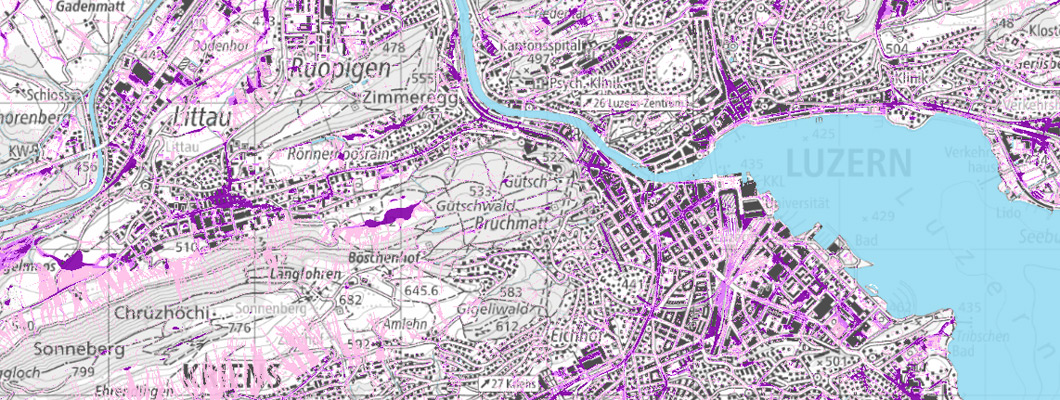
洪水灾害图:防洪必不可少的地图。用户欣赏仿真速度和仿真结果的清晰度。
堤防违规建模:软件模型的强大计算性能与预仿真相结合,使得堤防违规操作成为可能。
保留措施效率的模型:提供关于计划的防止大雨或洪水的措施是否会达到预期效果的确定性。
● 淹没区域和淹没深度的流体动力学建模
● 大坝和堤坝泄漏的模拟
● 在空间上可变的水位或水文图上进行/去除高达500点
● 模拟具有可变径流系数的暴雨事件(边坡径流危险)
● 自动生成动画电影(.avi),以提高您的客户的意识
● 输出流路分析的流向
● 考虑不包括在地形模型中的流动障碍(堤防,铁路堤坝等)
● 二维流体动力学建模
● 在任意点输入/输出水
● CPU和几个内核的并行化,可进行快速计算
● 与水位有关的粗糙度值或基于阈值的粗糙度值的变化
● 可选配管网模型cePipe,模拟下水道网络
● 同时为不同分区使用多个降水水位图
● 模拟过程中径流系数的时间变化
● 考虑将可变水位作为约束条件
● 可以集成水泵
● 输出流向和流速
● 中断和恢复仿真,以及更改参数
● 自动生成动画电影
● 根据输出数据生成流量曲线
● ArcGIS的® 集成
● 支持集成到自动化流程(模型构建器,批处理脚本等)中
FloodAreaHPC 11 is the next generation of
the established software model for the
calculation of floods. Thanks to the
complete renewal, you get more
functionalities and the integration of a
sewer network model in addition to more
performance and better handling:
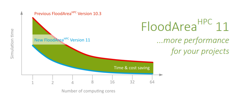
+ Optimization of computing
performance: Enables you to model
even larger areas and to complete
your projects even faster. Each
doubling of computing cores doubles
your modeling speed.
+ Flexible combination of all
FloodAreaHPC functionalities: This
allows you to design the complexity of
your scenarios as required.
+ Water level-dependent roughness: It is
now possible to change the roughness
above a threshold value — You can
Also model roughness changes due to
a rise of the water level, for example in
case of dike breaches or linear flow
processes.
+ Variable water level over time is
possible: Modelling of increasing and
decreasing water levels in a water
body.
+ Simultaneous use of several
precipitation hydrographs in the
project area: Sprinkle any number of
separate subareas with different
hydrographs, for example to display
pluviometers or grid cells of a radar
image. You can simulate dynamic
(temporal and spatial) events with
detailed precipitation data.
+ Temporal variation of runoff
coefficients: No external scripting is
required for changing the runoff
coefficients over time. This makes your
simulation more stable and faster and
it also reduces rounding errors to
almost zero.
+ New file formats: better readability
and therefore better handling and
fewer errors when creating these files.
+ Elimination of separate pre-processing:
Everything is integrated into the model
core, this makes processing faster and
more stable.
+ Coupling with sewer model: If the
sewer system has a high influence on
your modeling task, simply couple
FloodAreaHPC with cePipe.
+ More output information:
FloodAreaHPC provides important
values for error checking and thus for
optimizing your quality control.
+ Web-based manual: Always access the
latest version and easy to use.
+ New price list: The multi-core versions
got cheaper. You get even more
performance for your money. With an
update subscription you save an
additional 25% of the update fee
● ArcGIS 版本 10.5 或更高版本
● 一台装有 Windows 10 或更高版本的电脑
● 至少 2 GB 主内存。
可编辑栅格图层的大小取决于可用的主内存。增加虚拟主内存的大小并不能解决这个问题,因为增加虚拟主内存的使用会大大降低计算速度。所需的硬盘存储在很大程度上取决于模拟的中间输出步骤(以 GeoTIFF 的形式)的数量和大小。
 北京友万信息科技有限公司,英文全称:Beijing Uone Info&Tech Co.,Ltd ( Uone-Tech )是中国大陆领先的教育和科学软件分销商,已在中国300多所高校建立了可靠的分销渠道。拥有最成功的教学资源和数据管理专家。如需申请软件采购及老版本更新升级请联系我们,咨询热线:010-56548231 ,咨询邮箱:info@uone-tech.cn 感谢您的支持与关注。
地址:北京市昌平区中兴路21号院4号楼5层516 网站备案号:京ICP备16049373号-1]
联系方式:+86-10-56548231
